BY DEBAJYOTI CHAKRABORTY
DEHRADUN, 4 OCTOBER 2022
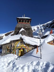
A twenty second 360 degree video footage shared in a social networking site by a Norwegian diplomat Erik Solheim on a Mahadev Mandir in Rudraprayag district of Uttarakhand , which is touted as the world’s highest located Lord Shiva Temple, Tungnath has already become the poster boy of Tourism of Incredible India after it went viral.
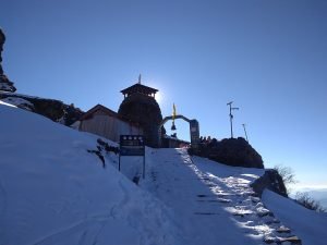
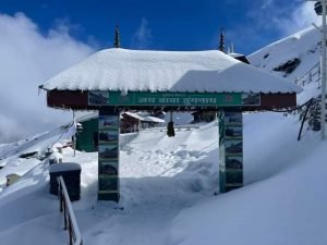
Through drone cameras the mesmerising aerial view has been captured of the five thousand year old Lord Shiva Temple (according to Uttarakhand Tourism Development Board) standing tall draped by the snow clad mountain peaks in the surroundings and clear sky.
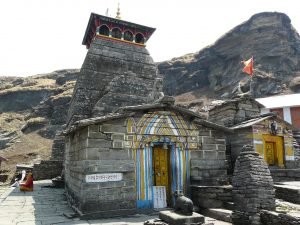
Tungnath is the highest of the five Panch Kedar temples located in the Rudraprayag. It is located at an altitude of 12,106 feet , and just below the peak of Chandrashila. It has a rich legend linked to the Pandavas, heroes of the epic Mahabharata .
HISTORY AND LEGEND :
According to Hindu mythology, Shiva and his consort, Parvati both reside in the Himalayas: Shiva resides at Mount Kailash. Parvati is also called Shailaputri, which means ‘Daughter of the Mountain’. Many folk legends related to the Garhwal region, Shiva and the creation of the Panch Kedar temples are narrated.
A folk legend about Panch Kedar relates to the Pandavas, the heroes of the Hindu epic Mahabharata. The Pandavas defeated and slayed their cousins — the Kauravas in the epic Kurukshetra war. They wished to atone for the sins of committing fratricide (gotra hatya) and Brāhmanahatya (killing of Brahmins — the priest class) during the war. Thus, they handed over the reins of their kingdom to their kin and left in search of Shiva and to seek his blessings. First, they went to the holy city of Varanasi (Kashi), believed to be Shiva’s favourite city and known for its Kashi Vishwanath Temple. But, Shiva wanted to avoid them as he was deeply incensed by the death and dishonesty at the Kurukshetra war and was, therefore, insensitive to Pandavas’ prayers. Therefore, he assumed the form of a bull (Nandi) and hid in the Garhwal region.
Not finding Shiva in Varanasi, the Pandavas went to Garhwal Himalayas. Bhima, the second of the five Pandava brothers, then standing astride two mountains, started to look for Shiva. He saw a bull grazing near Guptakashi (“hidden Kashi” — the name derived from the hiding act of Shiva). Bhima immediately recognized the bull to be Shiva. Bhima caught hold of the bull by its tail and hind legs. But the bull-formed Shiva disappeared into the ground to later reappear in parts, with the hump raising in Kedarnath, the arms appearing in Tungnath, the face showing up at Rudranath, the nabhi (navel) and stomach surfacing in Madhyamaheshwar and the hair appearing in Kalpeshwar. The Pandavas, pleased with this reappearance in five different forms, built temples at the five places for venerating and worshipping Shiva. The Pandavas were thus freed from their sins.
READ ALSO – TURNING A NEW LEAF : MOONLIGHT TEA PLUCKING- THE MAKAIBARI WAY
A variant of the tale credits Bhima for not only catching the bull, but also stopping it from disappearing. Consequently, the bull was torn asunder into five parts and appeared at five locations in the Kedar Khand of Garhwal region of the Himalayas. After building the Panch Kedar Temples, the Pandavas meditated at Kedarnath for salvation, performed yagna (fire sacrifice) and then through the heavenly path called the Mahapanth (also called Swargarohini), attained heaven or salvation. The Panch Kedar Temples are constructed in the North-Indian Himalayan Temple “Katyuri” architecture with the Kedarnath, Tungnath and Madhyamaheshwar temples looking similar.
After completing the pilgrimage of Shiva’s darshan at the Panch Kedar Temples, it is an unwritten religious rite to visit Vishnu at the Badrinath Temple, as a final affirmative proof by the devotee that he has sought blessings of Shiva.
Legend also states that Rama, the central character of Ramayana, meditated at the Chandrashila peak which is close to Tungnath, in India. It is also said that Ravana performed penance to Shiva, the lord of the peaks, when he resided here.
GEOGRAPHY :
Tungnath is at the top of the ridge dividing the waters of the Mandakini River (rising from Kedarnath) from those of the Alaknanda River (rising above Badrinath). The Tungnath peak on this ridge is the source of three springs, which form the Akashkamini River. The temple lies about 2 km below the Chandrashila Peak at about 12,106 ft. The road to Chopta is just below this ridge and hence provides the
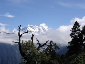
shortest bridle approach path for trekking to the temple from Chopta, over a short distance of about 5 kilometers . From the top of the Chandrashila peak, picturesque views of the Himalayan range comprising snow peaks of Nanda Devi, Panch Chuli, Bandarpoonch, Kedarnath, Chaukhamba and Neelkanth on one side, and the Garhwal valley on the opposite side could be witnessed. The valley between Chopta and Tunganath temple has wooded hills with rich alpine meadows with rhododendron coppices and also agricultural fields. The rhododendrons, when they are in full bloom during March, display dazzling colours ranging from crimson to pink. A high-altitude botanical station of the Garhwal University is located here. Near the top of the temple, there is a forest rest house at Dugalbitta, just opposite to the Kedarnath range of hills. The Kedarnath WildLife Sanctuary, also called the Kedarnath Musk Deer Sanctuary, set up in 1972 to preserve the endangered musk deer, which lies in the region, also has a musk deer breeding centre at Kharchula Kharak near Chopta.
It is also a birding paradise and over 240 species of birds are found here including both the native and migratory species.
READ ALSO – THE ROAD THAT CAN CHANGE THE FACE OF TOURISM IN KALIMPONG
CLIMATE :
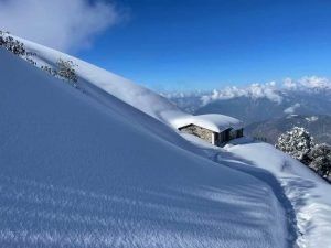
Climate is generally cool throughout the year. Summers are pleasant with average temperature hovering around 16 degrees Celsius during the day time. Winters are very chilly and temperature drops below the freezing point very frequently. The best time to visit the temple is from April to September. Due to heavy snowfall, the Tungnath Temple remains closed for around 6 months during winter.
HOW TO REACH :
A Four kilometre trek from Chopta, a small hill station, popularly known as the mini Switzerland of Uttarakhand.
Jolly Grant Airport is the nearest airport situated about a distance of 221 kilometres. Chopta is well connected by road and taxis are available from the airport.

The nearest railway station is Rishikesh situated about 202 kilometres away on NH58. Taxis and buses ply on the route.Buses and taxis are available from major destinations of Uttarakhand.
Incredible India 🇮🇳!
World's Highest Located Mahadev Mandir.., believed to be 5000 years old !
Uttarakhand— Erik Solheim (@ErikSolheim) October 2, 2022

Advertisement:








Add Comment